
Belton Street Directory Walkthrough
A useful Belton street search begins with the parcel, not a presumed household. Bell Central Appraisal District can connect a street number and name to a public parcel card. That card supplies identifiers for the map and a legal description for the recorded-instrument search. Ownership, a tax mailing field, and an address on the ground are different facts. The result is a documented address trail, not a complete list of everyone connected with a street.
- Enter the whole address in Bell CAD. If it fails, simplify to the street and number, then try the street name without its type as CAD recommends.
- Save the property ID, geographic ID, map ID, situs, mailing field, tax year, and legal description exactly as displayed.
- Open the county map and inspect the parcel feature and nearby features. Record the selected layer and the date before treating the map as geographic context.
- Use the current owner or legal description in the Bell County Official Records Search to locate related recorded instruments and dates.
- For a specific registration question, use VoteTexas rather than trying to build a street roster. Historical street entries, if found, need a dated directory or newspaper source.
The order matters. Parcel identifiers and legal descriptions usually hold steadier than a common name or a display address, so they reduce false matches as the Belton street directory moves from current records to older material.
Belton Street Directory CAD Fields
Bell CAD offers By Owner, ARB Search, and Advanced modes. Advanced search is particularly useful for a street directory because it can narrow a result without assuming that a name belongs to a current occupant. CAD describes the property ID as the quickest route when it is known, and allows results to be downloaded as CSV or emailed. The search fields below are the published labels available for parcel research.
| Field label | Search use | Format or caution |
|---|---|---|
| Owner Name; Owner ID; Doing Business As | Find a recorded tax-roll relationship | Use a unique name portion; a business may appear under DBA. |
| Street Number; Street Name | Locate a parcel by address | Try the full address first, then simplify and omit the street type if needed. |
| Property ID; Geographic ID | Return to one parcel or join it to map context | Copy the identifier exactly rather than trying to decode it. |
| Subdivision; Neighborhood; Abstract; Condo; MobileHomePark | Narrow an address where a street search is broad | These fields describe parcel context, not household membership. |
| Property Type; Tax Year; Agent Id | Limit the result set by assessment context | Current and prior-year data can differ with certification and updates. |
| Protest Status; Informal Date; Hearing Date; Board Members; Formal Date | Review appraisal-protest context | These fields concern the appraisal process, not an address history. |
A parcel card can show owner and agent fields, ownership percentage, values, a land table, map ID, legal description, and exemption indicators. It may also suppress exemption information for privacy. Bell CAD cautions that legal descriptions and acreage need verification for legal use, and that current data may lag a sale, correction, protest, or certification update.
The Bell CAD parcel-card capture illustrates the published card layout for an address-level search.
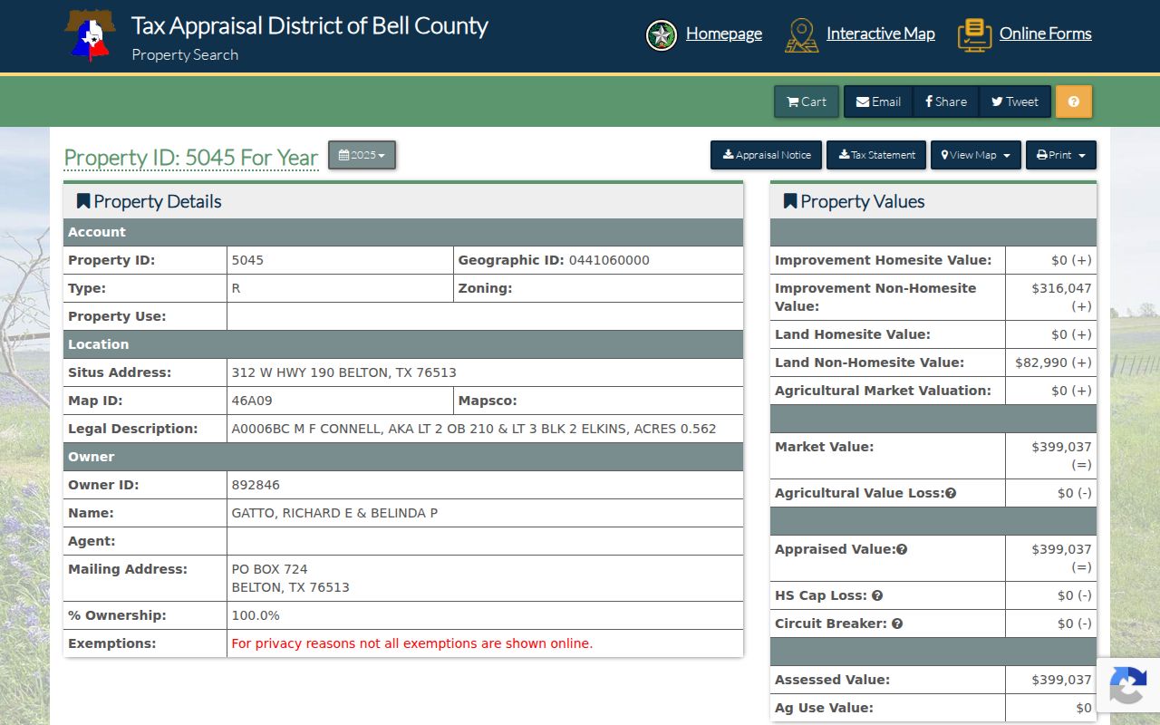
The displayed example includes separate situs and mailing fields, property and geographic identifiers, a map ID, legal-description text, tax-year context, and a land table. It is a field-level illustration, not a finding about a person or household.
Belton Street Directory Address Labels
Keep CAD's situs and mailing fields in separate notes. The situs is the location Bell CAD identifies for the parcel. The mailing field is where tax correspondence goes. A PO Box, trust, company, agent, or another city can appear in a mailing field without proving that its addressee occupies the Belton situs. The same caution applies when an owner name is present: it documents an appraisal or recorded-ownership relationship, not every person at the property.
The parcel card is a bridge between systems. Its geographic ID and property ID connect the tax-roll record to GIS; its map ID supplies map context; and its legal description supports a deed or plat search. A homestead exemption may be consistent with owner occupancy, but it is not conclusive proof of present occupancy or of who else may be associated with an address.
Note: Record the displayed tax year and certification status before comparing a Belton mailing field with a current street address.
Belton Records by Street Address
Each address-keyed source answers a narrower question. Start with the CAD card, then use the map and a recorded instrument to test the connection. City permit or code material may provide addressed work and dates if released, but no anonymous Belton permit or code archive was confirmed during research. A focused request should name the address, record type, date range, and desired public fields rather than ask the City to create a directory.
| Address record | Custodian | What it can show | Access path |
|---|---|---|---|
| CAD parcel card | Bell CAD | Situs, mailing, parcel IDs, legal description, values, and tax-roll ownership fields | Public parcel search with privacy and legal-use caveats. |
| Parcel and boundary feature | Bell County and City ArcGIS | Geometry, adjacent features, city limits, ETJ, and district context | Public web map or feature service; schema varies by layer. |
| Recorded deed or index entry | Bell County Clerk | Recorded parties, instrument, date, and legal-description language | Official Records Search, CountyFusion, or older books and microfilm. |
| Plat or subdivision record | Clerk, CAD, and GIS | Lot, block, subdivision, and mapped relation | Search the legal description and subdivision terms. |
| Permit or code file | City of Belton | Addressed work, responsible applicant, and dates if public | Defined request; public search was not confirmed. |
| Historical directory or newspaper | Library, TSLAC, UNT, or museum | Date-specific street household or business lead | Repository and edition must be verified because the Belton run is unresolved. |
The County Clerk also offers historical fallback routes. The Texas State Library and Archives Commission guide documents Bell County deed records from 1850 through 1902 and overlapping deed indexes. Confirm holding-library and reproduction rules before relying on a microfilm lead. The Official Records Search does not publish a verified first online year, so an apparent online gap is not proof that the instrument never existed.
Belton Streets in GIS Layers
The Bell County ArcGIS web map provides the map side of a Belton street directory. Zoom to the road, select a parcel or boundary layer, open a feature, and retain the layer name, map extent, and any map or feature ID. Use that result to return to the individual CAD card. The public research did not establish a complete selection-tool manual, so describe a feature only as the chosen layer displays it.
The City of Belton's Admin Boundaries FeatureServer adds City Limits, Neighboring Cities, Fort Hood, Bell County ETJs, TIRZ Boundary, and Belton ETJ layers. Those layers answer a geographic question. They do not identify an occupant. Shared driveways, easements, condominium units, and multi-parcel ownership can make a visual neighbor different from a legal adjacent parcel.
Note: If a parcel is absent from the map, check its CAD card and legal description before concluding that the record is missing.
Belton Street Deed Trails
A street directory becomes more reliable when a CAD result is tested against a recorded instrument. Search the current owner as grantee around the probable purchase period, then take the seller from that instrument and search backward as a prior grantee. Also use document number, recorded-date range, subdivision, lot or block, and legal-description terms. The Clerk index can surface a deed, deed of trust, release, correction, easement, replat, tax sale, foreclosure, or probate-related document, each of which has a distinct role.
Grantor means the party transferring an interest; grantee means the party receiving one. Neither label means resident. A release can explain an earlier security instrument without changing ownership. Keep each instrument as a dated observation, including its document type and legal-description language. For a property-recording question that the index cannot resolve, the Bell County Clerk publishes 254-933-5171 and deed.recording@bellcounty.texas.gov. For an older record not reached online, the Clerk, the Texas State Library guide, and holding-library microfilm routes are the documented alternatives.
Belton Street History Clues
Belton's courthouse-centered plan, later growth, and annexation history explain why a current street display can differ from an older map or record. The Comprehensive Plan's annexation material includes ordinance references, including annexations and a 2011 disannexation reference. Those records can turn a boundary question into a dated research trail. They do not prove that a house number changed, and the research did not locate a complete official master list of Belton street renamings or renumberings.
The documented record trail reaches well before electronic search. Bell County was organized in 1850, and the state-library guide lists commissioners-court minutes from 1850 to 1856, deeds from 1850 to 1902, marriages from 1850 to 1935, and death records beginning in 1903. Use a current CAD situs, a dated instrument or plat, and a historic map, directory, newspaper, or Sanborn sheet as separate checkpoints. If the legal description remains stable while a street label changes, preserve the source wording rather than forcing a match.
Belton Street Directory History
For a past street question, a reverse or criss-cross directory can connect a house number with a date-specific householder or business, but no complete Belton directory run was verified online. Treat an absent volume as a repository question, not a negative finding. The Texas State Library guide for Bell County, Belton Public Library, the Bell County Museum Research Library, UNT, and UT Briscoe are the documented places to ask about a year, title, street section, or map.
Sanborn material can establish what stood on a block at a particular time. The 1907 Belton item records buildings, construction, occupancy, property boundaries, and house or block numbers, while a 1921 item offers another checkpoint. These maps describe the built environment, not a complete household. Newspaper notices and local-history files may add a lead, but should be checked against a dated directory, deed, vital index, cemetery source, or map before a person is connected to an address.
For historical directory collections rather than a current address chain, see the Belton city directory resources.
Belton Street Directory Terms
These terms keep a street search from mixing a mapped parcel with a household claim. Use the source's exact label whenever possible, especially where a current address and an older legal description appear to disagree.
- Parcel
- A mapped unit of property used in the CAD and GIS context; it can have identifiers, boundaries, and a legal description.
- Situs address
- The property location shown on an appraisal record, distinct from the address used for tax correspondence.
- Plat
- A recorded map or subdivision document that can translate a street address into lot and block language.
- Criss-cross directory
- A historical street-address listing that may connect a number with a dated householder or business, depending on the edition.
Belton Street Directory Limits
Public address records have firm boundaries. A CAD card does not establish all occupants. GIS cannot establish occupancy. VoteTexas is for a specific registration question, not a public street roster, and protected displays may omit or mask an address. Utility, delivery, DMV, protected-voter, and many non-owner records are not an ordinary public street source. A responsible result can be limited to a parcel, a recorded party, or an unresolved address connection.
Texas Public Information Act requests seek existing government records and may be subject to withholding or redaction. For a City record that is not publicly indexed, use the Belton JustFOIA request portal with a specific address, date range, department, record type, and preferred electronic format. Ask for segregable public portions and the cited exception if information is withheld.
Lawful use. Use Belton street records for personal, lawful research such as property history, family history, or civic questions. Do not use them to stalk, harass, intimidate, or harm any person, and do not try to reconstruct a protected address.